
By Peru specialist Chloe
Northern Peru is truly like a forgotten land. Most overseas visitors never set foot here, but don’t discount it on those grounds. So, why should you go?
To experience a part of undeveloped Peru where deep-seated traditions still hold sway. To embark on scenic walks in the eastern Andes and off-the-beaten-track birdwatching. To visit barely excavated pre-Inca ruins that, for years, lay undiscovered, smothered in cloudforest or tucked into rocky overhangs.
Where to go in northern Peru
You can explore all the places I mention below over a two-week trip. Bear in mind that some long — though extremely scenic — road transfers are essential for getting around northern Peru; domestic flights don’t really exist here. You also have the option to bring northern Peru into a wider tour of the country. Over two weeks you can visit some of the Northern Kingdom’s main sites before flying into Cuzco to pick up the classic tour of the Sacred Valley and Machu Picchu.
The Chachapoyas and Leymebamba region
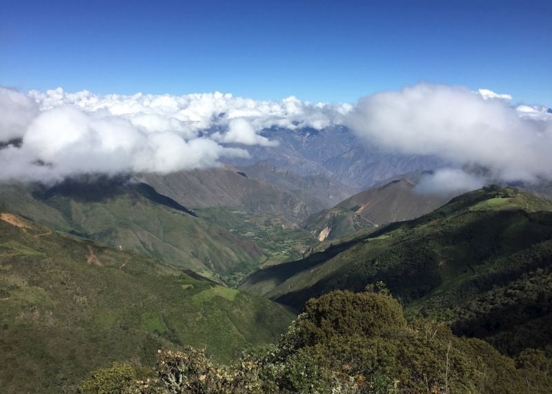
From the second you step out of the car in the Chachapoyas region the air feels moist, as if newly rinsed. Bromeliads cling to tree trunks, and you might catch hummingbirds flitting past, their wings beating a rapid tattoo. You’re now in cloudforest.
It’s an area where weekly calendars revolve around the local cattle market. Legend and folklore abound: waterfalls are jealously guarded by mermaids, and the screech of an owl can curdle the blood of local people, for whom it signifies the ‘cry of death’. All mischief or unexplained happenings are attributed to sprite-like creatures called duende.
Gocta Waterfalls
A three-and-a-half-hour drive from Jaen Airport (a 90-minute flight from Lima) brings you to Cocachimba, a hamlet set in a misty area of forest-clad mountainsides.
Cocachimba offers little more than a village-square-come-makeshift-football-pitch and a couple of shops, but it’s the gateway to Gocta Waterfalls. This double-tiered cataract appears like a smoke trail at the end of a U-shaped rock face.
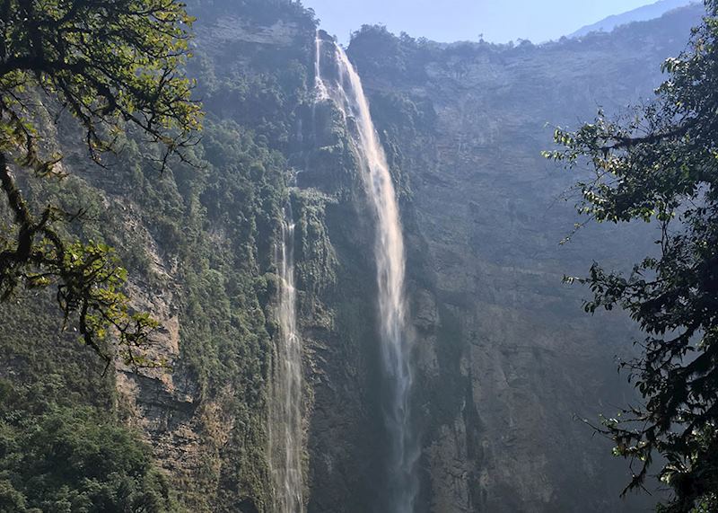
There are a couple of restful places to stay in Cocachimba where you can wake to prime views of the falls and start a hike on the well-marked jungle track to the falls’ plunge pool.
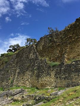
Kuélap — the landmark Chachapoya settlement
The Chachapoya culture (800 to 1476 AD — the name roughly translates to ‘cloud warriors’, a possible reference to their foggy homeland) built this limestone brick settlement running directly north to south along an escarpment 3,000 m (9,843 ft) above sea level.
It’s protected with backfilled walls 20 m (66 ft) high and looks like a fortress, though current thinking compares it to the Vatican, a religious or ceremonial nucleus whose walls signified power and prestige. All around the site lie yawning mountain passes, one with a great looping syncline visible in its exposed strata.
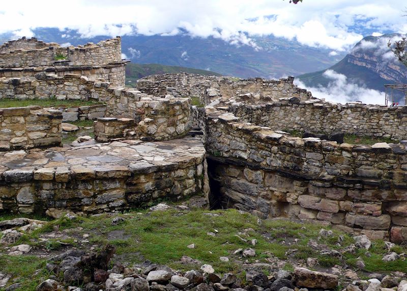
Inside the ramparts, cloudforest has partly reclaimed the ruins. Unlike Machu Picchu, Kuélap’s vegetation has been partly left to run wild. Trees, mosses, orchids and fuchsia have wiggled their way into the site’s drystone roundhouses in a way that reminded me of Cambodia’s Ta Prohm. The greenery helps wick away water, contributing to the site’s preservation.
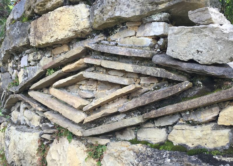
Other shapes emerge as you explore: a watchtower, buildings decorated with enigmatic friezes of zigzags and rhombuses, and an inverted cone-like construction named El Tintero (‘The Inkwell’). Its purpose has intrigued archaeologists; theories range from solar observatory to bone depository.
Getting there is also fun: you take a 20-minute cable car trip over a forested gully with sweeping views of the surrounding mountains. Tip: minutes after you set off, look back at the rock face to glimpse some human remains — including a skull — stashed in difficult-to-reach burial niches.
Kuélap is best visited en route from Gocta to the whitewashed highland town of Chachapoyas, which makes a pleasant base for exploring the area.
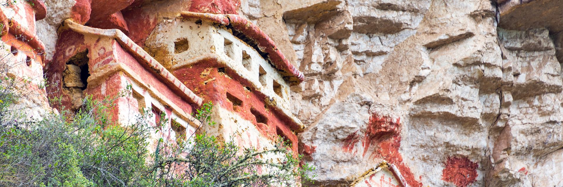
Walking to the tombs of Revash
Revash is less archaeological ruin, more scenic experience. The only way to witness this 13th-century burial site of the Revash culture is on foot.
The wide, paved trail begins in a modest highland village, and you’ll pass through outlying homes and smallholdings before reaching a cliff-edge. Itinerant chickens, schoolchildren dwarfed by enormous backpacks, and the occasional villager leading a pony share the first section of path with you. You then traverse the cliff’s flanks on a narrow, stony track to reach a viewing platform.
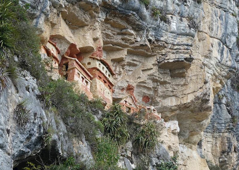
Opposite and slightly above sit chullpas (funerary buildings or tombs) constructed into an overhang on an impregnable-looking limestone cliff face. In fact, most of the tombs were looted by huaqueros (grave robbers or treasure hunters), leaving only skeletal remains inside. But the chullpas, which resemble miniature reddish mudbrick cottages, are largely intact, along with a series of red pictograms. Their meanings have been largely lost, but one is thought to represent a sacred feline figure.
Leymebamba Museum
From Revash it’s roughly a 90-minute drive to Leymebamba. This village’s greatest claim to fame is its museum, home to the 800-year-old Chachapoya mummies found at a remote sierra lake, Laguna de los Cóndores.
The museum displays Chachapoya textiles — some remarkably well-preserved — as well as oddities including trepanned skulls, a bone flute, and a mummified possum.
But it’s the 219 mummies that are the headline attraction. Stacked on shelves in a musty room, some half-wrenched from their wrappings, they stare back at you from hunched positions. Some have their hands clamped over their eyes, as if playing a ghoulish game of peekaboo. Some are still encased in their shrouds, which bear oddly childish-looking stitched faces.
In and around Cajamarca
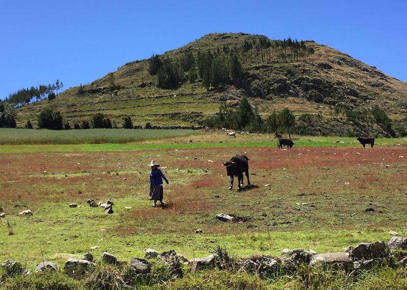
The drive from Leymebamba to Cajamarca, a boutique colonial town set in a fertile dairy-farming valley, is long — around nine hours of snaking mountain road.
However, the only traffic you’re likely to encounter is free-roaming livestock. My driver pulled over at times to let me walk for a little way along the empty road and admire the views. The Andes rise up around you, the mountainsides flecked with splashes of magenta from wild bougainvillea and indigo blue from jacaranda. There’s also the odd brownish patch where farmers have lit fires, believing the smoke will bring rain.
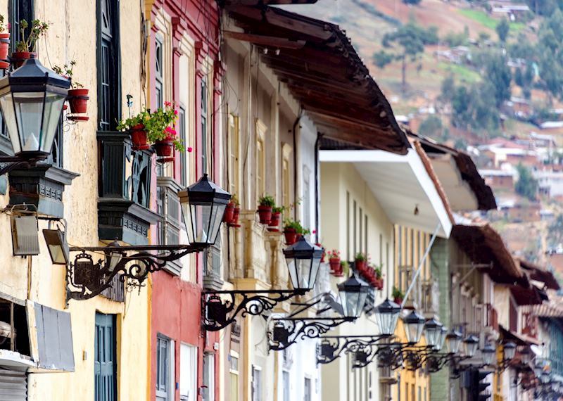
Cajamarca, the town
This pleasantly walkable cluster of cobblestone streets has a large, fountained central plaza that acts as the town’s de facto living room. Just off this main square, hidden away amid plateresque churches and other colonial relics, is the Cuarto del Rescate (Ransom Room). Inca emperor Atahualpa bargained with Pizarro to fill this room with treasure in exchange for his freedom.
Peek through the trapezoidal doorway and you’ll see niches where idols and war trophies were kept, as well as the stone on which Atahualpa was eventually executed. Precisely tessellated stonework aside, it’s an unremarkable ruin, but a good guide can bring it to life. Mine, Manuel, regaled me with (unapologetically biased) tales of how Atahualpa verbally sparred with Pizarro, exposing the conquistador’s illiteracy.
Cumbe Mayo, a pre-Inca aqueduct
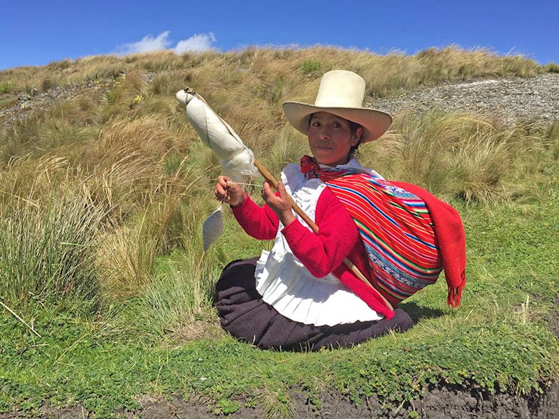
Reaching this site created by the Cajamarca culture (circa 500 to 1000 AD) involves a 45-minute drive out of Cajamarca up a bumpy, chicaning mountain road, the altimeter ticking up to 3,500 m (11,482 ft). As you climb, you’ll glimpse highland women wearing traditional dress of wide skirts and rainbow-patterned shawls. They sport tall straw hats in place of the squatter, bowler styles seen in the south.
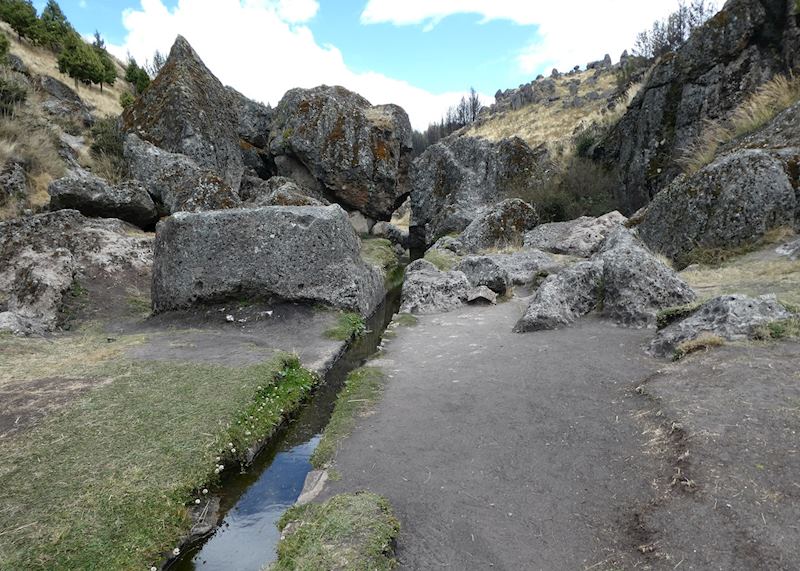
Cumbe Mayo (‘thin stream’ in Quechua) is the well-preserved remains of a pre-Inca aqueduct or canal. Like Revash, it’s less of a ruin, more of a good walk. You pass through a winding dale peppered with gorse-like yellow bushes, the air ringing with the cawing of Andean rockpeckers.
Spiked crowns of glacially sculpted columns known as Las Frailones (the Tall Friars) rise up around the dale, some standing up to 60 m (196 ft). Their surfaces have eroded into shapes resembling human faces. The local explanation for their humanoid appearance is livelier: they were originally wrongdoers who were petrified in an electrical storm sent by Pachacamac, the Inca creator-god.
Manuel led me to an area where the canal disappeared under a weighty boulder, or rather an altar. Surprisingly, Cumbe Mayo’s water wasn’t used for irrigation but for religious rituals. Manuel pointed out where the straight-sided channel suddenly entered a couple of carefully crafted zig-zags, which represented the sacred staircase, or the path to heaven.
In and around Chiclayo
From Cajamarca it’s a very long drive to the coast, swapping highland scenery for flatter, sandy coastal plains. The northern coast is a desert hinterland quite divorced from more familiar images of a green, mountainous Peru.
Chiclayo is an unprepossessing town, little more than a base for exploring the nearby sites. That said, it does have some winsome quirks. Pop your head into the Mercado de Brujos (witches’ market), where witch-doctors ply the customer with a cabinet of curiosities: dried herbs, powders and packaged remedies claiming to cure a host of ills, from headaches to heartache. There are also stalls piled with luscious produce, from tuna (prickly pears) to lúcuma, a fleshy, nutty-caramel fruit beloved of northerners. Try it in ice-cream form.
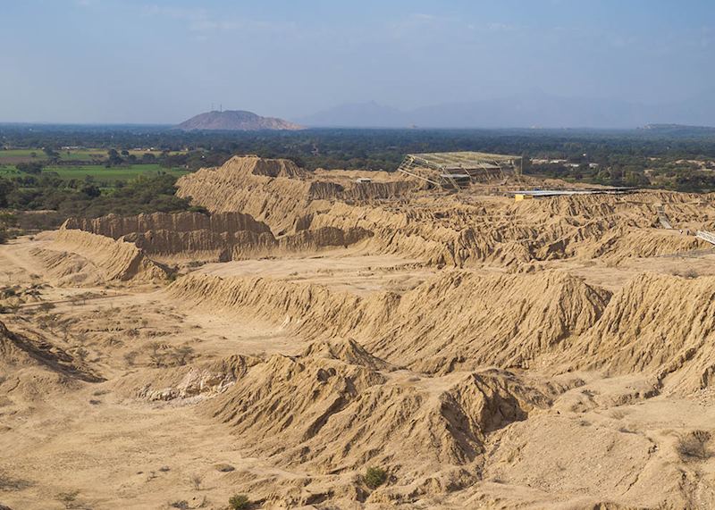
The pyramids of Túcume
A 45-minute drive from Chiclayo brings you to a parched valley of dun-shaded, low-lying mounds, their trapezoidal sides gouged with runnels from rainwater. They’re 26 (mostly) as-yet-unexcavated burial pyramids made of adobe mudbricks, created by the Sicán culture who began work here around 1100 AD. Locals coexist with this gargantuan archaeological site with their usual placid pragmatism: I was tickled to see that someone had planted a vegetable patch at the foot of one of the pyramids.
You walk through a scorched, scrubby landscape of carob and sapote forest to enter the main pyramid-studded valley. Keep your eyes peeled for burrowing owls, vermilion flycatchers, and the bright flash of a blue-headed whip-tailed lizard.
When I visited, the valley seemed abandoned (save for a few brooding vultures), with all of the main excavations closed to the public. This is par for the course in northern Peru, but it does mean you’re likely to see professionals digging or testing out new technology.
I recommend climbing the sinuous path to the mirador (viewpoint) on the Cerro Purgatorio (Purgatory Hill) for views over the scattered pyramids rising from the hazy plains of desert scrub, dry forest and sugar cane.
Museum of the Royal Tombs of Sipán
The town of Lambayeque lies around 20 minutes from Chiclayo by road, and it’s the proud owner of one of the best museums in South America. This scarlet Toblerone of a structure was purpose-built to house the priceless objects discovered by Peruvian archaeologist Walter Alva in the tomb of a Moche noble known as the Lord of Sipán. (The original burial site is about 48 km (30 miles) away).
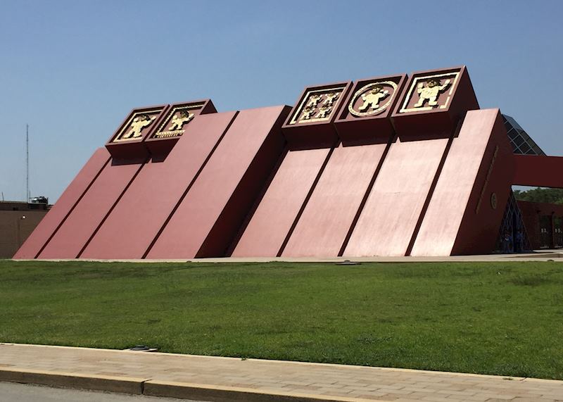
The museum is cannily structured. Information boards track the progression of the original dig opposite the cleaned-up exhibits, presented in the order they were found. First, you see a single gold rattle. Then 1,137 clay pots, believed to be offerings. Then the skeleton of a sentry, whose feet were removed so he was unable to flee his post. All these things, Alva knew, indicated that some VIP was buried close by.
Descending deeper into the building, you enter the areas devoted to the countless relics found buried with the Lord of Sipán himself — his body was wrapped in combat dress, with multiple outfits and adornments for the afterlife. They include earrings with astoundingly detailed metallurgy, a collar of stylized gold and silver peanuts, and several pectorals fabricated of tiny white seashells. With case after case of gold, gilded copper, lapis lazuli, and bronze relics, it’s easy to become quickly overwhelmed with the riches on display.
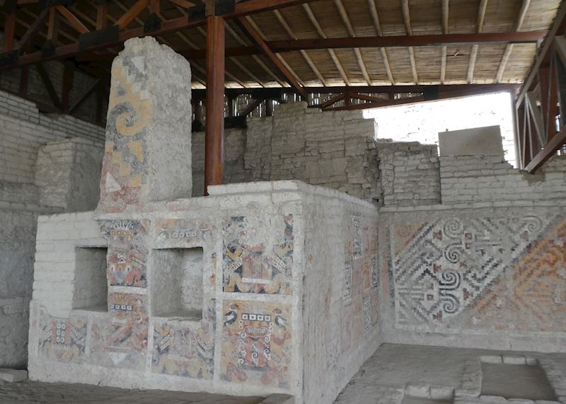
The temples of El Brujo
From Chiclayo it’s around a two-hour drive to El Brujo, a truncated, stepped pyramid complex created by the Moche culture (200 BC to 600 AD).
At moments on this journey, you’d be forgiven for thinking you’d wandered into a desert-like version of Southeast Asia: the highway splices paddy fields, rice being a staple part of the diet in the coastal north. Look for great bags of it being sold by the roadside.
You then follow the Pan-American Highway south, moving out of the desert and into the surprisingly verdant Chicama Valley with its maize and asparagus plantations. Snow-white cattle egrets pick their way through the stalks.
El Brujo rises out of nowhere at the end of a long minor road that comes out at the slate-grey Pacific — the background rumble of its waves accompanies you around the site. A lone armed guard stands watch at the top of the main ruin, the Temple Cao, like a knight prowling battlements.
The Temple Cao itself is a 30 m (98 ft) high pyramid made out of adobe mudbricks. It’s a bizarre Russian doll of a structure in which outer temples were built around earlier ones by successive generations every time a priest (thought to have been the leaders of Moche society) died.
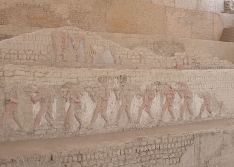
El Brujo’s strangeness is immediate. An area in front of the Temple Cao appears sprinkled with bits of pottery and other archaeological detritus. But a closer glance reveals a white lump to be a human pelvic bone. Around it lie scraps of tattered cloth — original Moche textiles, preserved in centuries of dust. ‘We can’t walk there,’ said my guide, Janette, matter-of-factly. ‘A lot of this place is still being investigated.’ Archaeology in northern Peru is thrillingly in the raw.
Giant friezes embellish the temple façades. One depicts a line of well-endowed prisoners being led to sacrificial slaughter. ‘We think the victims were made to drink a hallucinatory brew that made them… stand to attention,’ said Janette, with a wry smile. Then she pointed to another set of bas-reliefs. ‘Look: human foot bones.’ I squinted at some dancer-like figures. Sure enough, lumps of whitish bone slotted into the wall, forming the figures’ ankles.
It’s easy to forget that all these walls were originally brilliantly painted, and you get a better sense of this when you reach the crest of the complex. Here, near the main altar, a restored panel reveals the demonic face of Ai Apaec, a key Moche god who bears the amiable moniker of ‘the decapitator’. He leers at you in brash shades of yellow, red and blue created from local minerals.
Farther into the temple, the wall reliefs become steadily more intricate, reaching their zenith at the burial place of a shamanic female mummy known as the Lady of Cao. Around her tomb, the walls are a riot of carved symbols important to the Moche, including pelicans and catfish. They’re all arranged in geometric designs so precise and linearly they look almost anachronistic, like a Pre-Inca PAC-MAN computer game.
The adjacent museum is the final resting place of the Lady herself. Her mummified remains lie in a glass case at the end of a darkened room, her arms and legs tattooed with snake and other animal designs, the ink etched deep into her remaining skin. Yet, her well-preserved remains are almost outshone by the finery from her tomb and funerary wrappings displayed around her. You’ll see a gilded copper headdress with a snarling feline face, jewels, gold staffs, hunting blowpipes, minuscule gold needles and a necklace of skull-like faces, their eyes made from tiny flecks of turquoise.
In and around Trujillo
From El Brujo, you continue for two hours south down the Pan-American Highway to the city of Trujillo. To your left, dune-like hills melt into the distance; to your right, across a dusty plain, the ocean breaks in gusty rollers along a driftwood-strewn shore. Trujillo Airport is incidentally the exit point for flights to Lima (one hour and ten minutes away) or from which you can pick up a connecting flight to Cuzco.
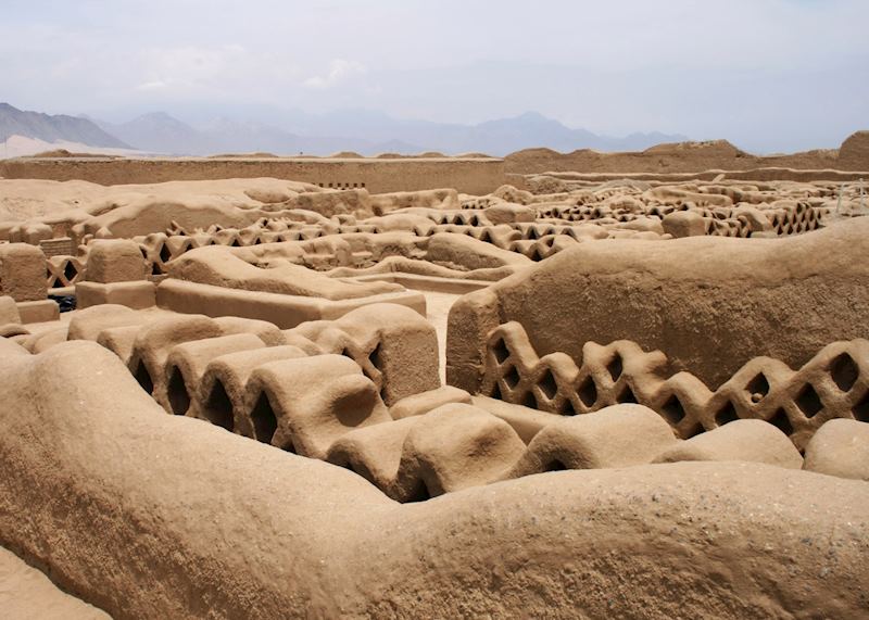
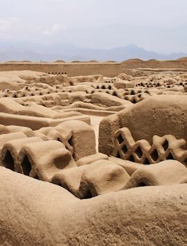
Chan Chan
Trujillo bisects the remnants of Chan Chan, a sprawling adobe city built by the Chimú culture between 1000 and 1476 AD and preserved by the desert conditions. As you drive in, you might notice clusters of reeds among the sun-baked earth — remains of ponds that once served as Chan Chan’s water supply.
With the high mudbrick walls glowing golden in the late afternoon sun, it feels more Valley of the Kings than Peruvian edifice. It all seems inscrutable at first, but your eyes gradually home in on the details. Some areas have intricate friezes of geometric and zoomorphic designs along with lattice-like walling that lets in breezes from the nearby ocean.
Start planning your trip to Northern Peru
Start thinking about your experience. These itineraries are simply suggestions for how you could enjoy some of the same experiences as our specialists. They’re just for inspiration, because your trip will be created around your particular tastes.
View All Tours in PeruFurther reading
Plan your trip
Tell us about your plans and one of our specialists will plan a unique trip for you...
Make an enquiryRequest our brochure, The World Your Way

Order your digital copy via email.
Request a brochure